Monday 30 March 2015

One of the most significant and beautiful pilgrimage centers of the Hindus, Rudraprayag is located in the state of Uttarakhand and is a municipality town in the Rudraprayag district. 
 Rudraprayag gets its name from the word “Rudra” which means, an aspect of Lord Shiva. According to mythology, Lord Shiva appeared to bless Narad Muni as Rudra. Since then, the place has been a sacred place for Shiva worshippers.
 The grandiose look of Rudraprayag is accredited to the existence of the great Rivers: Mandakini and Alaknanda. Apart from the natural beauty, Rudraprayag offers an outstanding opportunity for those who love adventure and recreational activities.
 Rudyraprayag is picturesque, the mighty Himalayas towering up, gushing waters of the two rivers at its feet and scenic greenery on all sides.
 The region around Rudraprayag is full of scenic beauty, lakes and glaciers and temples of religious importance.
Its picturesque beauty and mesmerizing charm draws a lot of tourists round the year. 
How to Reach
By Air
The nearest airport is Jolly Grant Airport of Dehradun. It is located approximately 158 km from Rudraprayag.
By Rail
The nearest railway stations to Rudraprayag are Kotdwar, located at a distance of 173 km and Rishikesh, situated at a distance of 140 km. 
By Road
Rudraprayag is well-connected by a network of roads. Almost all the major towns and cities of the region like Dehradun, Rishikesh, Kotdwar, Pauri, Joshimath, Gopeshwar, Badrinath, Kedarnath, Nainital, Almora and Delhi are well linked with Rudraprayag by motorable roads. From Delhi, one has to take NH 58 to Rudraprayag which is about 337 Km away, via Meerut. Haridwar, Rishikesh, Devprayag and Srinagar.
Book your  Rudraprayag holidays with our affiliate partner Booking.com

Rudraprayag - Uttarakhand – India

Sunday 29 March 2015

The land of spirituality, Rishikesh in the state of Uttarakhand is one of the most renowned pilgrimage centers in India. One of the biggest religious centers of North India, Rishikesh is situated along the banks of the holy Ganges and surrounded by the verdant Shivalik hills on three sides. 
 Rishikesh is a delightful place to wander around and explore on foot. Cross either of the two suspension bridges and you'll be rewarded with spectacular views of the town and river. Venture down to the ghats fronting the river and relax for a while amidst the daily goings-on. You can also take a boat across the river near Ram Jhula as an alternative to walking.
 Rishikesh has today emerged as a prime center of Yoga. The effectiveness of Yoga as a means to stay well is proved beyond doubt and has gained tremendous popularity across the globe. A lot of people travel to Rishikesh to learn the art of Yoga and rejuvenate the soul.
 An annual International Yoga Festival (March 1-7 international yogafestival) is organized jointly by Uttarakhand Tourism and Parmarth Niketan Ashram
 Rishikesh is frequented by Hindu pilgrims as well as westerners who set out to the Ganges to cleanse them of their sins and attain nirvana. Dotted with temples exuding divinity and ashrams soaking in the holistic environs, Rishikesh is a major attraction for those seeking spirituality.
 It is believed that the confluence of Ganga, Yamuna and Saraswati took place here. This ghat is large and clean, Many ashrams in Rishikesh offer short and long-term courses in yoga. Some of the most respected names are the Sivananda Ashram, Omkarananda Patanjala Yoga Kendra, Parmarth Niketan and Yoga Niketan Ashram
 Today Rishikesh means different things to different people. For the spiritually inclined, it’s the yoga capital of the world, for the adventure lovers it is a rafting paradise, and for the tourists a perfect blend of all - spirituality, adventure, sightseeing and shopping.
Aptly titled the ‘Yoga Capital of the World’, Rishikesh has umpteen ashrams organizing yoga camps across the year. Thousands visit Rishikesh to relax, learn yoga, meditate and seek spiritual bliss. 
How to Reach
By Air
The nearest airport around Rishikesh is Jolly Grant Airport in Dehradun that is located at a distance of 35 km. Regular flights at the airport are available. It is purely a domestic airport.
By Road
Rishikesh has an excellent network of buses linking it with all the major cities and towns nearby. Luxury as well as normal deluxe buses are easily available from New Delhi's ISBT Kashmiri Gate at regular intervals. 
By Train
Rishikesh has its own railway station but it is not connected to major Indian cities apart from Haridwar. So, the nearest major railhead is in Haridwar, which is well-connected with cities like Delhi, Mumbai, Lucknow and Varanasi via an extensive network of trains.
Book your Rishikesh holidays with our affiliate partner Booking.com

Rishikesh - Uttarakhand – India

Saturday 28 March 2015

Pithoragarh is a district in the state of Uttarakhand and serves as a gateway to the mighty Himalayan ranges. It is located in the beautiful Soar Valley and is bordered by the Almora District in the north. 
 Most of the ancient temples and forts were constructed here during the reign of the Pal and Chand dynasties. In the 15th century, the region was controlled by the Brahm Kings for a short period. Later, the kings of the Chand Dynasty restored their rule and reigned till the British took over.
  It is a beautiful small town which lies in the heart of the western half of the Soar Valley. Pithoragarh is so beautiful that it even seems to resemble the Kashmir valley on a miniature scale. It is very pretty and scattered with villages.
 Pithoragarh is in the inner Himalayas at a height of 1,851 meters in a spectacular valley situated in the northern state of Uttaranchal.
 Pithoragarh is rich in natural beauty and it offers best view of the Himalaya.The town itself is the starting point for the Hindu pilgrimage route of the Kailash Mansarovar Yatra, and other mountaineering expeditions to peaks such as Nanda Devi, Trishuli, and the Panchchuli ranges.
 The valley is flanked by four hills - Chandak, Dhwaj, Thal Kedar and Kundar - and is dramatic in its beauty.
 This beautiful tourist destination is known for its scenic views of the snow-capped peaks of Panch Chulhi, Nanda Devi,
 The breath-taking and magnificent beauty of the mighty Himalayas attracts a large number of tourists around the year. The picturesque area offers you a variety of flora and fauna to see.
 The town has a number of hospitals, cinemas and hotels as it a stopover for travelers to mountaineering base camps and trekking routes. It also has a quite a few scenic spots and temples around it worth visiting.
Pithoragarh has a cool climate which makes it comfortable all year round. 
How to Reach
By Air
The nearest airport to Pithoragarh is located at Naini-Saini, about 5 kms from the Pithoragarh town. Other than this, the Pant Nagar Airport is the second nearest airport to Pithoragarh. 
By Rail
The nearest railway station from Pithoragarh is Tanakpur, about 151 kms. Another option is the Kathgodam Railway Station (212 kms) in Nainital District.
By Road
Pithoragarh is well connected to nearest major towns like Champawat, Lohaghat, Munsiyari and Tanakpur. From Delhi, you have to take NH24 to Moradabad from where NH87 will lead to Kathgodam. From Kathgodam, taking district roads you will reach Pithoragarh via Almora, Panuanaula, Dhyari and Rameshwar.
Book your  Pithoragarh holidays with our affiliate partner Booking.com

Pithoragarh - Uttarakhand – India

Saturday 21 March 2015

Har Ki Pauri is a famous ghat on the banks of the Ganges in Haridwar in Uttarakhand state in India. This revered place is the major landmark of the holy city of Haridwar. Literally, "Har" means "Lord Shiva" who is the god according to shaivite school of Hindu theology, "ki" means "of" and "pauri" means "steps". Lord Shiva and Lord Vishnu are believed to have visited the Brahmakund in Har ki Paudi in the Vedic (ancient period) times. There is a large footprint said to belong to Lord Vishnu on a stone wall.
 Thousands of devotees and pilgrims flock here from all over the world to take a holy dip; it is believed that a dip here will wash away their sins or Karma and provide Moksha.
 The ghat is on the west bank of Ganges canal through which the Ganges is diverted just to the north. Har ki pauri is also the area where thousands of pilgrims converge and the festivities commence during the Kumbha Mela, which takes place every twelve years, and the Ardh Kumbh Mela, which takes place every six years and the Punjabi festival of Vaisakhi, a harvest festival occurring every year in the month of April.
 Har ki pauri is believed to be the exit point of the river Ganges from the mountains and its entry into the plains. A dip in the holy water of the ghat is said to relieve a person of all his sins. The place is surrounded by some ancient and some newly build temples.
 King Vikramaditya constructed this sacred ghat in memory of his brother Bhatrihari who it is believed had come to Haridwar to meditate on the banks of the Ganga.
 Every day, Hari Ki Pauri ghat witnesses hundreds taking a dip in water of the Ganges. Each evening at sunset priests perform Ganga Arti here, when lights are set on the water to drift downstream. This is the most amazing and soul touching spectacle. A large number of people gather on both the banks of river Ganges to sing its praises. The priest hold large fire bowls in their hands, the gongs in the temples at the Ghat start ringing and the chants flowing out of lips fill the air. People float earthen diyas, with burning flickers and flowers in them as a symbol of hope and wishes .The golden hues of floral diyas reflected in the river Ganges present the most enchanting sight.
 An area within Hari ki Pauri, where the evening Ganga Aarti takes places and which is considered most sacred is known as Brahm Kund.
 The Har Ki Pauri temple carries even more significance, because it preserves the footprints of Lord Shiva even to this day. The scene at the Ganges ghats can itself stir your soul and immerse you in the ocean of devotion. The entire ghat remains lined with saints, rishihs and pilgrims.
The place is considered very auspicious. Over the years the ghats have undergone major extension and renovation as the crowds increased in subsequent Kumbh Melas. 
How to Reach
Its only 05 km far from Haridwar, 215 km from Delhi, 50 km from Dehradun, 45 km from Jolly Grant Airport Dehradun,30 km from Rishikesh, 85 km from Mussoorie. You can go by the Rickshaw to the Temple and auto (Tuk TUk) is also available for Har ki Pauri.
Book your  Har ki Pauri  holidays with our affiliate partner Booking.com

Har ki Pauri - Uttarakhand – India

Monday 16 March 2015

Nestled in the Uttarakhand Himalayas, Nainital is a sparkling gem in the Himalayan stretch which is gifted with fascinating natural splendour and a variety of natural resources. One of the oldest and the most popular hill stations of the country. Nainital is a perfect getaway from the plains of northern India and has been named after the legendary Naini Lake which is in the shape of an eye. 
 The town is actually made up of two areas, Tallital and Mallital, which are on either end of the lake, surrounded by mountains and connected by The Mall. Nainital is the perfect place to come and simply enjoy nature and the pristine views, which you’ll find in abundance there.
The city’s charm is only added to with the hundreds of ancient temples and peaks with amazing views of the mountains in the backdrop. 
  Nainital called the Lake District of India is the home of four Lakes of Kumaon hills- Naini Lake, Sattal Lake, Bhimtal Lake and the Naukuchiyatal Lake.
 It is enriched with the different lakes and its dense forests which attracts the visitors to spend their leisure time in the lap of nature.
 The place is set in a valley containing the pear-shaped Naini lake, approximately two miles in circumference and surrounded by mountains.
 While activities like boating and exploring caves are major crowd pullers, a visit to the Jim Corbett National Park is an absolute must. The oldest national park in India, it is home to the endangered Bengal Tiger.
It is an excellent year-round weekend getaway and also a great base to explore the numerous beautiful villages and scenic spots in the Kumaon region.
How to Reach
By Air
Being a hill station, Nainital does not have direct air connectivity. The nearest airport is located at Pantnagar, which lies at a distance of 65 kilometres from Nainital.
By Bus
Nainital enjoys excellent bus connectivity to important destinations in North India. Several tour operators operate daily bus service from New Delhi to Nainital, which includes options like air-conditioned, non-air-conditioned, sleeper and Volvo buses. Boarding an overnight bus is the most convenient way to head to Nainital, although some buses operate during the daytime as well.
By Train
The nearest railway station is located at a distance of 34 kilometres at Kathgodham, at the foothills of the Kumaon hills. Kathgodam railway station enjoys good connectivity to important places such as Delhi, Lucknow and Howrah, with daily trains running to New Delhi.
Book your  Nainital holidays with our affiliate partner Booking.com

Nainital - Uttarakhand – India

Wednesday 11 March 2015

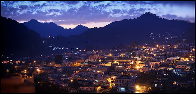
Mussoorie  is a well-known hill station nestled in the Dehradun District of Uttarakhand in the region of North India. Being situated in the foothills of the Garhwal Himalayan ranges it is often referred to as the Queen of the Hills.
  In 1820, a British Army officer set up this town. Mussoorie is not only famed for its picturesque splendor but it has also urbanized into an imperative center of education and trade over the course of time.
 The Shedup Choepelling Temple located on the Happy Valley road in Mussoorie was the Dalai Lama’s first place of refuge when he fled Tibet. While the route to the temple is quite narrow and lacking in sign boards, most of the locals will be happy to help you make your way to it.
 The name of the place is derived from the Mansur shrub established in profusion around this region. Vestiges of its colonial past are still reflected in the architecture of this town.
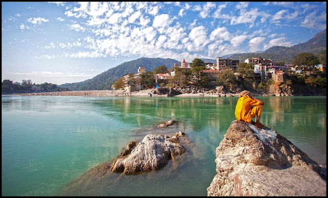
 Nestled in the Himalayan foothills it reflects a royal look with its dense jungles, comfortable atmosphere and the wonderful views of the Doon Valley.
 Its green hills and varied fauna and flora make it a colourful and picturesque hill station, commanding a wonderful view of extensive Himalayan snow ranges to the North-East, and Panoramic view of the Doon valley to the south.
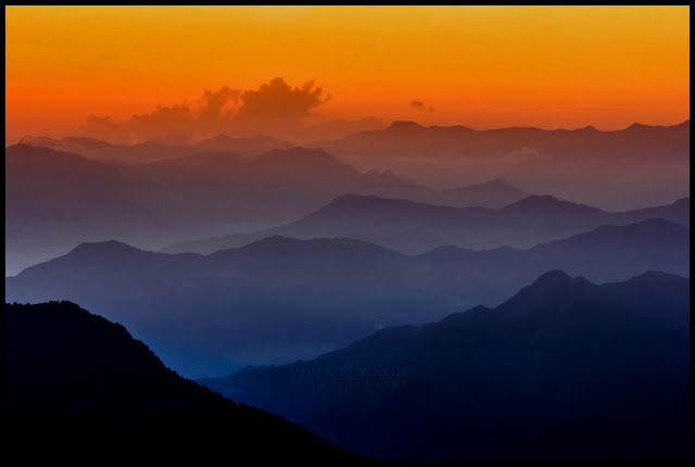
 The Queen City lies in the foothills of the beautiful Himalayan ranges. It seems to be very calm while viewing the beautiful sight of foggy mountains in Mussoorie.
 The scenic beauty of this place can be felt in its snow capped mountains, lush greenery and enlivening breeze. Situated on the foothills, Mussoorie offers captivating view of the immense mountain ranges.
 Mussoorie will surely offer you a distinct hill station experience as compared to other places.
Ranging from enthralling views of the panoramic valleys and hills to exciting treks, leisurely walks and endless shopping opportunities, Mussoorie has everything in place to make a memorable holiday
How to Reach
By Air
Without a domestic Mussoorie Airport, there are no direct flights to Mussoorie, although certain flights arrive at the Jolly Grant Airport in Dehradun to transport passengers to Mussoorie, through a break journey covering a distance of 24 km by road.
By Train
As such Mussoorie does not have a direct rail link. Dehradun Railway station serves for Mussoorie too. This station is linked which Superfast trains to other major cities in country. The nearest railhead is Dehradun which is 34 Kms. from Mussoorie. It is the Northern Railway terminus connected to all major cities such as New Delhi, Mumbai, Howrah, Lucknow, Varanasi, Amritsar, Saharanpur, Haridwar, Rishikesh, Allahabad, Ujjain, Indore, Kathgodam, Okha. 
By Road

Mussoorie is only 35 kms from Dehradun. From Dehradun to Mussoorie one can hire a taxi or take a bus to Mussoorie. Mussoorie is well connected with roads with other major cities.
Book your  Mussoorie holidays with our affiliate partner Booking.com

Mussoorie - Uttarakhand – India

Monday 9 March 2015

The name Mukteshwar is a derivation of two Sanskrit words - one is "mukhti" that means eternal life and the other "ishwar" which stands for God, pointing to Lord Shiva. Mukteshwar is also spiritually or religiously known as Mukteshwar Dham. It is a tranquil and peaceful city and one of the busiest pilgrimage destinations in Nainital district of Uttarakhand State. This spiritual site is dedicated to Lord Shiva. Both pilgrims as well as tourists visit this holy place in good numbers.
 It  is a hilly region comprising of beautiful fruit orchards and wonderous coniferous forests.Deriving its name from the name of Lord Shiva, it is a beautiful tourist destination situated at a height of 7500 feet above the sea level in the Kumaon hills.
 It is picturesquely located in the lap of Kumaon hills. The entire region is circled with the dense fruit orchards and forests. This beautiful places was also discovered during the British era.
 The evergreen forests and deciduous woodlands are home to the Himalayan ruby throat, white-crested laughing thrush, red-billed leothrix, black winged kite and a host of other mountain birds.
      It is a calm and peaceful town that offers enchanting views of the amazing surroundings.
 It is a natural scenic beauty and gives the enchanting view of Himalayan’s second highest peak Nanda Devi. As it is a hilly area the agriculture here consists of fruit orchards and the potato fields .
 The second highest mountain-peak of India, Nanda Devi, is also visible from Mukteshwar. The other ranges one can see from Mukteshwar are Neelkantha (Blue-throated Shiva), Trishul (Shiva’s Trident), Nanadaghunti (the Veil of the Goddess), and the Panchuli Group.
 There is also a Renewable Park developed by The Energy and Resources Institute, which use solar electricity for most of its electricity needs. As the case in anywhere else in India, recently, the town has experienced some construction activity and townships have begun to mushroom in and around Mukteshwar.
Himalayas along with the lovely Pine and Deodar forests. Enjoy the beauty of sunrise and sunset at Bright End Corner.
How to Reach
By Air
Nearest airport is at Pantnagar, which is 111 km away. Another airport where travellers can fly to is the Jolly Grant airport at Dehradun. One can hire a taxi from the airport to reach Mukteshwar.
By Rail
The nearest railhead is at Kathgodam, 72 km, from where buses and taxis are available for Mukteshwar. There are regular trains that connect Kathgodam from Delhi.
By Bus
Mukteshwar is well connected to other cities in the state by road. Mukteshwar is 350 km from Delhi, a drive of about 8-9 hours via Nainital, 53 km away or Haldwani, 49 km away.
Book your  Mukteshwar holidays with our affiliate partner Booking.com

Mukteshwar - Uttarakhand – India